

The story of an erased global Tartarian empire and a recent worldwide mud flood is a modern conspiracy theory. Its central claims are unsupported, and several fail when tested against historical records. Calling it a myth is a judgement about the evidence, not an insult to people who have encountered the story.
An old map bearing the name Tartaria is a real historical object. A doorway below a pavement can be a real former entrance. Neither discovery, by itself, proves that a worldwide disaster buried an advanced civilisation and that its survivors had their history erased.
That is the central problem with the Tartaria and mud flood story: genuine objects are presented as evidence for conclusions they do not establish.
When we investigate the examples through maps, street records and construction photographs, a different picture emerges. We find changing geographical names, cities deliberately raising their streets, and impressive buildings whose construction was recorded. These explanations can be checked against specific places and dates.
What exactly is being claimed?
There is no single, agreed Tartaria theory. This article examines a common version: an advanced civilisation supposedly built monumental cities across the world; a relatively recent mud flood buried them; and later authorities concealed their origin. Some versions also claim that domes and spires collected electricity to power the old world.
These are claims made by proponents themselves. For example, the Tartaria Empire website connects a supposed nineteenth-century worldwide catastrophe with buried windows, inherited buildings, empty-city photographs and atmospheric energy. That website documents the argument being examined here; it is not independent evidence that the events happened. See the proponent’s account.
Where did the modern Tartaria story come from?
The old geographical name and the modern conspiracy story have different histories. Three Russian writers are especially important to distinguish: Anatoly Fomenko, Gleb Nosovsky and Nikolai Levashov.
Fomenko and Nosovsky: New Chronology. Fomenko, a mathematician, developed an alternative chronology that radically compresses accepted ancient and medieval history. With his coauthor Nosovsky, he promoted a Russian-centred reconstruction in which familiar historical accounts conceal a much larger empire. Historian Charles J. Halperin traces earlier influences, including Nikolai Morozov and Mikhail Postnikov, and discusses the expansion of Fomenko and Nosovsky’s popular publishing after the Soviet collapse. Their project predates 1991; it was not created by the later mud flood videos. Halperin, 2011, pp. 3–4.
Fomenko’s mathematical credentials do not settle the historical argument. The relevant question is whether his reconstruction survives checks against documents, languages, archaeology and chronology. Halperin’s assessment identifies serious problems in how Fomenko and Nosovsky use historical scholarship. Greg Melleuish, Konstantin Sheiko and Stephen Brown also examine Fomenko in a peer-reviewed study of pseudohistory, nationalism and the internet. These works critique New Chronology; neither should be presented as a study of every later mud flood claim. Melleuish, Sheiko and Brown, 2009.
Levashov: an alleged Slavonic-Aryan empire. A text dated 20 July 2003 on Levashov’s own website identifies Great Tartary with an ancient Slavonic-Aryan empire. It gives an explicitly Russian and Slavic identity to the supposed state. His sequel, dated 29 July 2004, invokes Fomenko and cites a book by Nosovsky and Fomenko in footnote 11. This is direct evidence connecting his secret-history narrative with New Chronology. It is not evidence that his supposed empire existed. Levashov, Part 1 and Part 2, footnote 11.
This helps explain why accounts of Tartaria’s origins often mention Fomenko and Levashov, while discussions of New Chronology refer to Fomenko and Nosovsky. They are two different pairings, and the writers’ reconstructions should not be treated as one identical theory.
The later online synthesis. The familiar narrative adds buried cities, inherited monumental buildings, suppressed energy technology and a recent worldwide catastrophe. A peer-reviewed study by religious-studies scholars Moritz Maurer and Thierry Göckel examines a Tartaria subreddit as a community imagining an erased, idealised past. Its publicly available abstract describes the community’s utopian and spiritual interpretation of that past. Maurer and Göckel, 2025, abstract.
The sources cited here establish intellectual connections and distinguish stages in the story. They do not establish a single inventor or first publication date for the entire worldwide mud flood package. Calling Fomenko and Levashov its joint inventors would go beyond that evidence.
1. Tartary was a real name, but a map label does not prove a global empire
Tartary, or Tartaria, really does appear on old maps. Denying that would be an easily disproved mistake.
The Library of Congress traces how European mapmakers used the name for changing areas of northern and central Asia. Some maps reflect ideas about the Mongol Empire; others use a broad geographical label covering different peoples and territories. Later maps distinguish several Tartaries rather than one unified state. Library of Congress: Tracking Tartary on Western Maps.
One useful example is John Cary’s 1806 map, preserved by the University of Texas at Arlington and accessible through the University of North Texas. Its title distinguishes Chinese and Independent Tartary. Readers can inspect the actual map rather than relying on a cropped screenshot. View Cary’s 1806 map.
The name’s existence establishes that mapmakers used it. Establishing a particular empire requires further evidence about rulers, institutions, territory and chronology. Establishing a worldwide technological civilisation requires considerably more.
Real Tatar peoples and the historical states of this region must not be confused with the modern claim of an erased global super-civilisation.
Historian Mark C. Elliott provides a detailed example of changing geographical terminology in his peer-reviewed article The Limits of Tartary. He traces how the name Manchuria emerged on nineteenth-century maps, gradually replacing an older regional label. His study concerns northeast Asia; it should not be stretched into a claim that every use of Tartary everywhere meant exactly the same thing. It does demonstrate that a disappearing name can be investigated through the history of mapping and imperial administration. Elliott, 2000, p. 603.
Guillaume de L’Isle, Carte de Tartarie (1706). Library of Congress, Geography and Map Division. Public domain. Source record ↗
2. Below-ground windows do not identify what happened to a building
A window below today’s pavement tells us where the window is now. It does not tell us when the surrounding ground reached that height, whether the room was originally a basement, or how the street changed.
Some lower floors really were once at street level. That is a reason to investigate their history, not a reason to jump straight to a worldwide catastrophe.
Three documented cases show why the distinction matters.
Chicago: The Illinois State Archives preserves an estimate for street construction dated 14 September 1855. Its accompanying historical explanation describes new street grades established in 1855 and 1856, requiring buildings to be elevated above the Chicago River’s water level. There is a documentary trail for deliberate changes to the city. Illinois State Archives: the 1855 document and explanation.
Urban historian Henry C. Binford independently places Chicago’s street raising within a decades-long effort, beginning in the 1850s, to make room for sewers and change the city’s water infrastructure. His account identifies engineer Ellis Chesbrough and explains the practical purpose of the work. This is a specific engineering history, rather than an inference drawn from a low window. Binford, “Multicentered Chicago,” section on speculation and engineering.

Edward Mendel, Lake Street building raising, catalogued as 1857. Chicago History Museum, via Wikimedia Commons. Public domain; Commons copy has tonal adjustments. Source record ↗
Sacramento: California State Parks explains that repeated local river floods prompted levee construction, river alterations and the physical raising of the business district’s streets. Raising streets and businesses took two decades. The underground spaces are real, and so were the floods. The evidence describes local disasters followed by a prolonged engineering response. California State Parks: Old Sacramento’s underground.
Seattle: The city’s account of Pioneer Square connects its underground with reconstruction after the fire of 6 June 1889. Filling low ground and raising street levels created the below-street spaces. City of Seattle: Pioneer Square Preservation District.
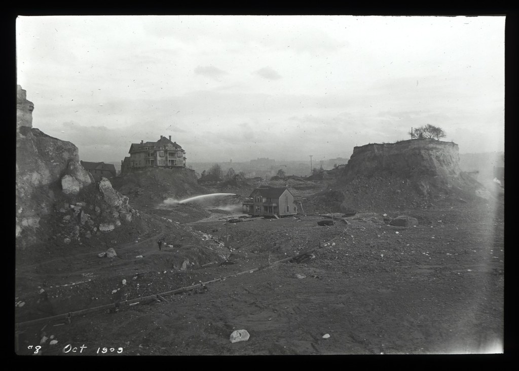
Courtesy of the Seattle Municipal Archives, #78094, Series 1204-03. October 1909. No editorial alterations. CC BY 2.0 Source record ↗
These cases do not explain every low window on Earth. They demonstrate why visually similar features cannot simply be assigned one global cause. At an unfamiliar building, the next step is to identify the address and check its plans, photographs, street history and excavation records.
3. World’s fair buildings have construction histories
Another claim is that nineteenth-century people could not have built the magnificent structures shown in world’s fair photographs. The buildings must therefore have been inherited from Tartaria.
Chicago’s 1893 World’s Columbian Exposition provides a direct test.
The Chicago Public Library holds the C. D. Arnold Photographic Collection: more than 1,000 prints, including photographs of dredging, landscaping and buildings under construction. Its catalogue identifies construction stages from 1891 onward, including named buildings and dated views. These are records readers can locate and compare with the finished fair. Explore the Arnold collection and its inventory.
The materials also matter. The library explains that most fair buildings used iron, steel and timber covered with staff, a temporary material containing plaster, cement and jute fibres. An ornate surface in a monochrome photograph is not proof of solid marble.
This does not mean every fair building was temporary or made in the same way. It means each building needs to be investigated individually.
The Library of Congress also catalogues a photograph of the Chicago exposition under construction. The claim that there are no construction photographs fails a straightforward archival check. Library of Congress: exposition construction photograph.
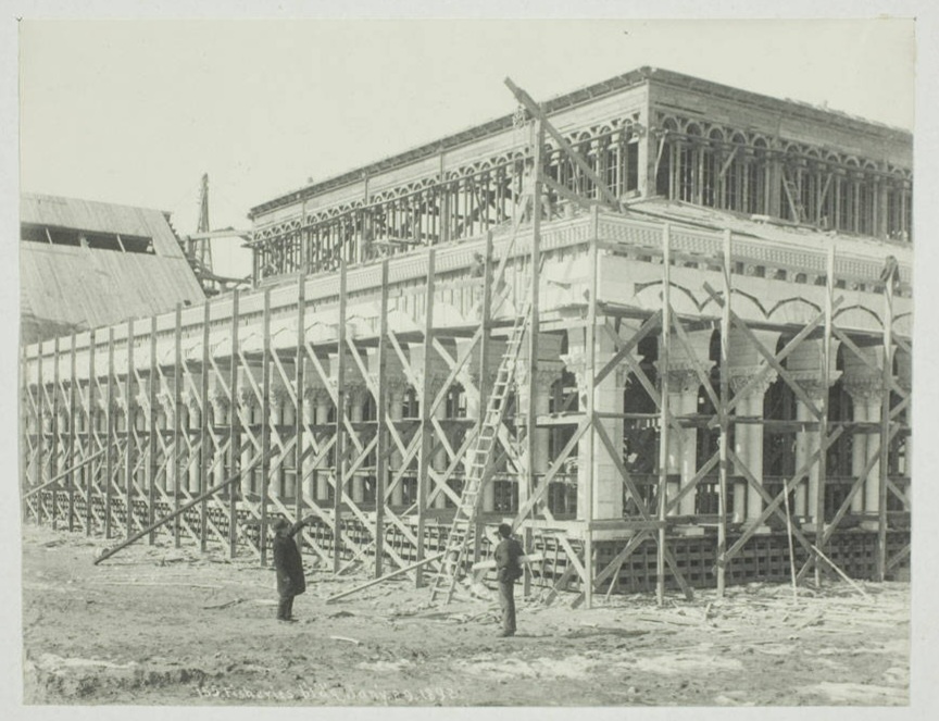
C. D. Arnold, Fisheries Building under construction for the World’s Columbian Exposition. Art Institute of Chicago collection, via Wikimedia Commons. Public domain. Source record ↗
Admiration for a building is not evidence that its documented builders were incapable of producing it. A challenge to the construction history needs to address the actual records.
4. An apparently empty photograph does not prove an empty civilisation
Old photographs can look strangely still. Sometimes the photographic process helps explain why.
The Library of Congress explains that the earliest daguerreotypes required exposures of three to fifteen minutes. Improvements soon reduced that time to less than a minute. During a sufficiently long exposure, people moving through a scene may fail to register clearly while buildings remain visible. Library of Congress: the daguerreotype medium.
That explanation must be used carefully. A photograph from later in the century cannot automatically be assigned the exposure time of the earliest daguerreotypes. First identify its date, process and circumstances. Time of day, location, framing and access to the site may also matter.
Even when an image genuinely shows an empty street, it records that view at that time. It does not establish that the city had no inhabitants, still less that humanity had recently been replaced.
5. Domes and spires do not demonstrate a lost electricity network
Some versions of the theory interpret metal roofs, domes and pointed finials as remnants of a system that collected atmospheric electricity.
Atmospheric electricity is real. The Smithsonian describes Benjamin Franklin’s experiments and the development of lightning protection, including conductors providing a path into the ground. The existence of electrical effects in the atmosphere is not the disputed point. Smithsonian: Franklin’s electrical experiments and lightning rods.
The missing step is evidence that particular buildings operated as the proposed power network. Where are the working components, connections, technical descriptions and measurements showing what energy was collected and what it powered?
We should not assume every spire was a lightning rod. Equally, calling a spire an antenna does not establish its function. Shape alone cannot tell us whether an object generated electricity, protected against lightning, or served another purpose.
6. A worldwide mud flood needs evidence connecting places and dates
Real mudflows and debris flows occur. The United States Geological Survey describes debris flows as rapidly moving mixtures of dirt, rocks, water and other material that travel from hillsides down valleys. Acknowledging such events does not establish the proposed worldwide historical reset. USGS: debris flows explained.
The global claim needs evidence showing that the allegedly buried sites belong to a coherent catastrophe. Photographs of unrelated excavations cannot supply that connection.
A useful investigation would ask:
- Where is each site, and what exactly was excavated?
- Is the material a natural deposit, construction fill, demolition rubble, or a combination?
- What evidence dates its deposition?
- Do independently investigated sites support the proposed event’s timing and extent?
- Does the explanation account for the local construction and street records?
This is a test of the claim, not a demand that every deposit look identical. A real disaster can leave different traces in different environments. What matters is demonstrating a connection rather than assuming one.
Street changes in different cities, at different dates, cannot establish a single event merely because photographs of their lower floors look similar.
7. What if the records were deliberately falsified?
Historical sources can contain mistakes, bias and deliberate deception. No archive becomes infallible because it is official.
But alleging fabrication creates another claim that needs evidence. If a construction photograph is said to be fake, investigate that photograph: its provenance, physical original, dating and relationship to other records. Simply dismissing every inconvenient document does not establish an alternative history.
A useful explanation must allow some possible discovery to count against it. If an absent record proves suppression while a surviving record proves forgery, the theory has insulated itself from testing.
Healthy scepticism applies the same standard to an exciting online video as it does to a museum catalogue. What is the source? Does it support the claim? Can someone else check it? What evidence would change the conclusion?
Historical chronology can be checked against more than written histories
An example comes from astronomy. In a peer-reviewed study, F. R. Stephenson, L. V. Morrison and C. Y. Hohenkerk analyse ancient and medieval eclipse observations and later observations of the Moon passing in front of stars to investigate changes in Earth’s rotation. Their data span records from 720 BC to AD 2015. Stephenson, Morrison and Hohenkerk, 2016, abstract and introduction.
That paper is not about Tartaria or mud floods. Its relevance here is methodological: historical observations can be compared with astronomical calculations. A proposal to rewrite chronology must account for such independent checks, rather than treating the accepted timeline as something resting on a single history book.
What the evidence supports
Tartary is a genuine historical name. Underground spaces are genuine features of some cities. Old buildings can be extraordinary achievements. None of those observations, alone or together, establishes the proposed lost global empire and worldwide mud flood.
The cases examined here have stronger explanations supported by records: changing map terminology, deliberate street raising, documented local disasters, construction sequences and the limitations of particular photographic processes.
An unidentified building or unexplained photograph can remain an open question. A gap in our knowledge does not automatically become evidence for Tartaria.
The erased global Tartarian empire and worldwide mud flood belong to a modern conspiracy myth. The historical name is real; the extraordinary story built around it is not supported by the evidence presented for it. The responsible response is to follow the records, investigate each site, and let the evidence determine the conclusion.
Sources and citations
Scholarly studies
- Mark C. Elliott. “The Limits of Tartary: Manchuria in Imperial and National Geographies.” The Journal of Asian Studies 59, no. 3 (2000): 603–646. Author-hosted full text. DOI: 10.2307/2658945.
- Charles J. Halperin. False Identity and Multiple Identities in Russian History: The Mongol Empire and Ivan the Terrible. The Carl Beck Papers in Russian and East European Studies 2103 (2011). Full text. DOI: 10.5195/cbp.2011.160.
- Greg Melleuish, Konstantin Sheiko and Stephen Brown. “Pseudo History/Weird History: Nationalism and the Internet.” History Compass 7, no. 6 (2009): 1484–1495. Publication and abstract.
- Moritz Maurer and Thierry Göckel. “The Tartarian Empire: Conspirituality, Pop Culture, and the End of the Past.” Nova Religio 29, no. 1 (2025): 5–34. Publication. University of Vienna record. Author-posted abstract. The discussion above uses the publicly available abstract; the full article was not available for verification.
- Henry C. Binford. “Multicentered Chicago.” The Encyclopedia of Chicago. Section “Speculation and Engineering, 1830–1880.” Full essay.
- F. R. Stephenson, L. V. Morrison and C. Y. Hohenkerk. “Measurement of the Earth’s Rotation: 720 BC to AD 2015.” Proceedings of the Royal Society A 472 (2016): 20160404. Open-access article. DOI: 10.1098/rspa.2016.0404.
Historical records, archives and technical explanations
- Amelia Raines, Library of Congress. Tracking “Tartary” on Western Maps, 20 June 2025. Cartographic context.
- John Cary, 1806. A New Map of Chinese & Independent Tartary. University of Texas at Arlington Library, via the Portal to Texas History.
- Illinois State Archives. Estimate for Street Construction, 14 September 1855. Reproduced historical document with modern archival explanation.
- Marcia Eymann, California State Parks. Old Sacramento Historic Underground Tours. Local flooding and deliberate street raising.
- City of Seattle. Pioneer Square Preservation District. Reconstruction and raised street levels.
- Chicago Public Library. C. D. Arnold Photographic Collection. Construction records and temporary fair-building materials.
- Library of Congress. World’s Columbian Exposition, Chicago, under construction and The Daguerreotype Medium.
- Smithsonian, National Museum of American History. Electrical Years, Part 2. Franklin’s experiments and lightning conductors.
- United States Geological Survey. Postfire Debris Flow Hazards: Tips to Keep You Safe, 2022. Description of real debris flows.
Proponents’ writings: evidence of the claims, not proof of their history
- Nikolai Levashov. The Untold History of Russia, Part 1, website text dated 20 July 2003; Part 2, dated 29 July 2004, especially footnote 11.
- Tartaria Empire. How Mud Floods Reset Our Civilization. A contemporary statement of the worldwide reset, architecture and energy claims.

